


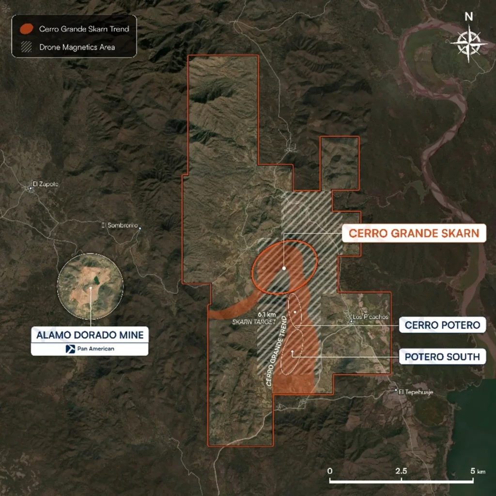
Algo Grande Copper (WKN A41UK1 / TSXV ALGR) is meticulously preparing the next exploration phase at its 100% owned copper project Adelita in the Mexican state of Sonora. The company has announced the launch of several geophysical and geochemical programs designed to refine target identification ahead of the planned Phase II drilling program in the second quarter of 2026. The focus is on a high-resolution LiDAR survey across the entire license area, a drone-based magnetic survey, and a systematic soil sampling program at the recently announced new discovery within the Cerro Grande target zone.
For Algo Grande, this step is particularly relevant because the next drilling phase is intended not only to build on already known zones but also to expand the system to a district-scale. The various datasets from structural geology, magnetics, and geochemistry will be integrated into the company’s three-dimensional geological model and machine-assisted target identification. With this, Algo Grande aims to improve the placement of future drill holes and increase the likelihood of more precisely delineating new mineralized areas.
Algo Grande Relies on Integrated Data Package Ahead of Drill Phase II
The new phase of work on Algo Grande’s property follows a clear pattern: Before the next drilling campaign begins, the geological understanding of the Adelita Project is to be significantly deepened. To this end, the company is combining three programs that capture different levels of the system. LiDAR surveying provides topographic and structural details; drone-based magnetic surveys are intended to make magnetite-rich skarn bodies and intrusive contacts more visible; and the soil sampling program aims to define geochemical patterns in an area that has been only limitedly sampled to date.
It is precisely this integration that is significant for Algo Grande. The company interprets Adelita as a structurally controlled system. Accordingly, it is important not only to map individual mineralized outcrops but also to trace the structures that could control mineralization. At the same time, the work is intended to extend the known mineralized profile beyond the already defined section.
Following the success of the first drilling program, Algo Grande is now focusing on the systematic expansion of the Adelita system. In particular, the Cerro Grande area remains a key focus because a mineralized zone has already been defined there, which is now to be further investigated along the strike and possibly also in connection with deeper-seated feeding structures.
LiDAR and Drone Magnetics to Sharpen Structural Imaging at Adelita
A key component is the high-resolution LiDAR survey that Algo Grande has now launched across the entire Adelita project. This is intended to better define structural corridors and fault systems that could be significant for mineralization. In addition, the company is searching for subtle alteration features and mineralized trends beneath overburden, as well as historical mining traces and previously unidentified exploration targets.
For Algo Grande, this provides a precise structural framework that is important for both skarn-altered zones and potential deeper-seated feeders. The company believes that, particularly in a structurally controlled system, better topographic and structural resolution can be directly translated into more accurate drilling planning.
In parallel, Algo Grande has commenced a high-resolution magnetic survey using drones over the more than six-kilometer-long promising mineralization corridor and adjacent target areas. This magnetic survey is intended to map intrusive contacts that could be associated with mineralizing systems. In addition, the aim is to delineate magnetite-rich skarn bodies and better identify structural controls as well as potential feeder zones for copper-gold-silver mineralization.
From Algo Grande’s perspective, the drone-based magnetic survey offers an advantage over older datasets because it has significantly higher resolution. This is likely to play an important role in defining the planned Phase II drill targets, particularly for identifying hidden skarn bodies and potential indications of a deeper porphyry source.
Geochemical Soil Program Focuses on New Area at Cerro Grande
The third part of the program is a systematic soil sampling grid in an area where mineralization was recently identified and where historical geochemical coverage is limited. Algo Grande’s primary objective there is to better understand the origin of a mineralized granodiorite sample found in early January. This sample was discovered at a depth of approximately one meter during the excavation of an access shaft for the Phase I drilling.
For Algo Grande, this discovery is geologically significant because it could point to a source of mineralization that has not yet been fully understood. The soil sampling program is therefore intended to define geochemical anomalies that can subsequently be prioritized for trenching and drilling. This is not merely a matter of selectively following up on a single find, but rather the systematic integration of a new target area into the broader framework of the Adelita Project.
The results from soil samples, magnetic surveys, and LiDAR will then be evaluated together. Algo Grande plans to feed these datasets into the existing 3D model as well as into machine-assisted targeting models. This should allow for more targeted selection of drill sites and better exploitation of the project’s discovery potential.
Algo Grande Aims to Broaden the Adelita Project Ahead of the Next Drill Phase
With the launch of the new programs, Algo Grande is demonstrating that the company intends to prepare for the second drilling phase at the Adelita Project with a broader and more technically robust data foundation. While the first drilling program already made the mineralized corridor at Cerro Grande more tangible, the work currently underway is intended to more clearly delineate the geological architecture on a district scale.
This applies both to the extension of the known skarn corridor and to the search for deeper or previously concealed zones. For Algo Grande, the added value of the current programs lies precisely in the fact that they define drilling targets not in isolation, but through the interplay of ge e structure, magnetics, and geochemistry. Prior to the launch of the Phase II program in the second quarter of 2026, the company intends to use this approach to prioritize those areas that, based on the new data sets, are most significant for the further development of the Adelita project.


