- TWO MAJOR STRUCTURES DISCOVERED BY LAKE IP SURVEY AND INITIAL DRILL HOLES
- SOUTH SHORE ANOMALY RELATED TO PYRITE SERICITE ZONE
- NORTH SHORE ANOMALY CONTAINS MASSIVE SULPHIDE BAND AND DISSEMINATED SULPHIDES IN SHEARS WITH OTHER ZONES OF SILICIFICATION-ALBITIZATION
Vancouver, March 22, 2021, Golden Goliath Resources Ltd. (TSX.V GNG ) (US: GGTH-F) (Frankfurt: GGZ)
Golden Goliath Resources is pleased to report that drilling of a new IP trend, partially generated by the survey on the frozen lake, has now been completed. Five holes (K21-17, 18, 19, 20, & 21 -see Fig. 5) have traced a sericite alteration zone with sections of intense silicification and sulphide content over 20%, for a 1.2 km distance between lines 1200E and 2400E. Some of this anomaly trend is on land and some sections are under the shore of the lake and in the bay adjacent to the West Grid. Those anomalies were generated by the IP survey conducted on the frozen lake (Fig. 2 & 3). It also extends westward from line 1200E across the water to line 600E on the West Grid. This anomaly is distinctive in shape and often shows a classic “pantleg” anomaly, a narrow chargeable anomaly near surface of 10m width. The south shore anomaly was tested first because the drill had already been moved to that area of the lake for access to water. Further infill drilling and undercut holes are anticipated for this trend once the access route has dried up and or refrozen.
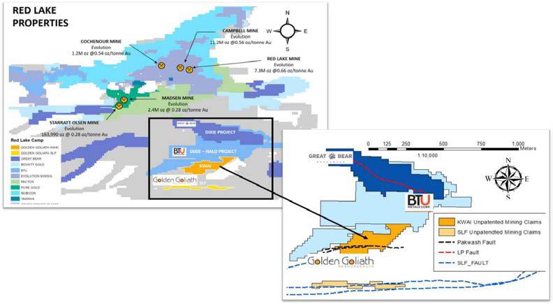
Figure 1: Red Lake District Properties including the Kwai and SLF properties of Golden Goliath
The drill has been moved to the new and very strong north shore anomaly, which is referred to by the Company as “the Whale” for both its size and shape. This strong, large target, also generated by the lake ice IP survey, occurs on lines 1800E, 1600E, 1400E and 2000E (Figures 2, 3 & 4). At least four initial holes are planned for the Whale anomaly. At the time of writing of this release, the first of these drill holes, K21-22, was completed on line 1800E to a depth of 175m. The hole intersected a 7m wide disseminated sulphide zone in sheared basalt, a 2m wide zone silicified and albitized zone and also a 0.5m wide massive pyrite zone, that is conductive and explains the resistivity low seen in the IP section. Deeper holes are also being considered for this highly promising target. Drill hole K21-23 is being initiated at this time.
The north shore anomalies, which lie along the main Pakwash Break, are distinctive in that they have the highest metal factors of any IP anomaly on the Kwai property. This is the result of a resistivity low coinciding with a chargeability high, suggesting a high sulphide content. This particular section of the Pakwash Fault lies 1400m east-northeast of a cluster of till samples on the West Grid containing high amounts of gold grains (Fig 3), both pristine and slightly modified in nature. A sulphide host source for these gold grains is anticipated given the number of pristine grains occurring in the oxidized till layer, therefore making these IP anomalies of special interest being high metal factor anomalies.
Overall, the IP survey conducted on the ice of Lake Beauregard has been very successful in Identifying important, high priority, drill targets and improving our geological knowledge of the property.
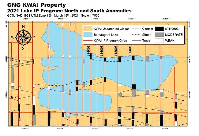
Fig 2: 2020-2021 IP Program with Surrounding Area
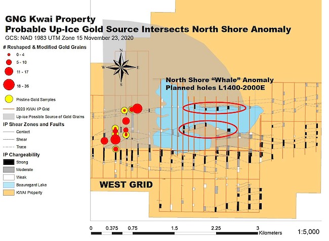
FIG. 3 Gold Grains Probable Source Area Plot From West Grid To Lake.
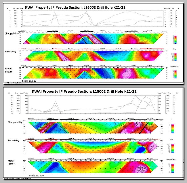
Fig 4: IP Pseudo Sections: Lines 1600 & 1800E with Drill Hole Locations and Dip
Prior to the extensive break in operations (February 8 until March 1) caused by extreme cold weather and drill problems, two drill holes (K21-15 and K21-16), were completed on lines 4900E and 4700E, about 2.3km east of Beauregard lake. These two holes were the first of a set of five holes planned to test an IP target trend that lies just south of the main Pakwash break, a second set of five holes is planned to test the IP targets on the north, along the Pakwash Fault itself.
The two completed drill holes on the East Grid were discussed in the Company’s press release from March 4, 2021. The drill was set up for the third hole in this sequence on Line 5100E, however the unexpected break in operations left the machine there, but the drill hole uninitiated. During the cold weather break, the water supply for this and other holes in the area froze solid. That required postponing drilling on these two East Grid IP trends. Consequently, the drill was moved to the southeast shore of the lake on the Central Grid where an IP anomaly from the ground IP work needed testing and water was available. On the East Grid, K21-15 and K21-16 intersected a basalt sequence south of the Pakwash Fault containing disseminated pyrite and chalcopyrite. However, no significant gold values were found. Assay results for drill holes completed after the unexpected break are still pending. Other holes in this area of the East Grid are still on hold pending resumption of the water supply.
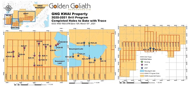
Fig 5: 2020-2021 Drill Program – Completed Holes to Date with Trac
This news release has been reviewed by Robert S. Middleton P.Eng who is acting as QP for this phase of the exploration under the NI 43-101 requirements.
On behalf of the Board of Directors
Paul Sorbara, MSc, PGeo
CEO, Golden Goliath Resources Ltd.
Cautionary Statements Regarding Forward Looking Information
Certain statements included herein may constitute “forward-looking statements”. All statements included in this press release that address future events, conditions or results, including in connection with exploration activity, future acquisitions and any financing, are forward-looking statements. These forward-looking statements can be identified by the use of words such as “may”, “must”, “plan”, “believe”, “expect”, “estimate”, “think”, “continue”, “should”, “will”, “could”, “intend”, “anticipate” or “future” or the negative forms thereof or similar variations. These forward-looking statements are based on certain assumptions and analyses made by management in light of their experiences and their perception of historical trends, current conditions and expected future developments, as well as other factors they believe are appropriate in the circumstances. These statements are subject to risks, uncertainties and assumptions, including those mentioned in the Company’s continuous disclosure documents, which can be found under its profile on SEDAR (www.sedar.com). Many of such risks and uncertainties are outside the control of the Company and could cause actual results to differ materially from those expressed or implied by such forward-looking statements. In making such forward-looking statements, management has relied upon a number of material factors and assumptions, on the basis of currently available information, for which there is no insurance that such information will prove accurate. All forward-looking statements are expressly qualified in their entirety by the cautionary statements set forth above. The Company is under no obligation, and expressly disclaims any intention or obligation, to update or revise any forward-looking statements, whether as a result of new information, future events or otherwise, except as expressly required by applicable law.
FOR MORE INFORMATION CONTACT:
Golden Goliath Resources Ltd.
J. Paul Sorbara, M.Sc., P.Geo
President & CEO
Phone: +1(604) 682-2950 Email: jps@goldengoliath.com
Neither TSX Venture Exchange nor its Regulation Services Provider (as that term is defined in the policies of the TSX Venture Exchange) accepts responsibility for the adequacy.
About Golden Goliath
Golden Goliath Resources Ltd. is a junior exploration company listed on the TSX Venture Exchange (symbol GNG). The Company is focused on exploring and developing the gold and silver potential of properties in the Red Lake District of Ontario. The Company also holds a 100% interest in the San Timoteo property, located in the Sierra Madre Occidental Mountains of northwestern Mexico, as well as NSR royalties on several other nearby properties.
To find out more about Golden Goliath visit our website at www.goldengoliath.com.


